Select, New, Edit, Copy, Delete

This section of the web tool allows you to start, select, delete, and save scenarios. The drop down box on the left gives you a list of your saved scenarios and allows you to select a scenario. If you are an agency owner you will see all the scenarios for your agency organized by user. The agency owner can view but not edit the scenarios created by other users. To create a new scenario use the green `New' button. Any unsaved changes to the current scenario will be deleted if you click the `New' button. To delete a scenario select the scenario using the drop down box and click the red `Remove' button. You will be promted that the scenario will be deleted and can not be recovered. To save the scenario use the blue `Save' button. We recommend that you use the `Save' button on a regualr basis to prevent loose of inputted data. Below the `Save' button is a message that is updated in realtime that shows when the last time the data was saved. The lower left hand of this section lets you know what agency you are affiliated with. If this is incorrect contact the user with agency owner privelages.
User Interface
This section of the user's guide outlines the basic user interface that applies to all input sections.
Tool Tips
Each field has a tool tip that will popup when the field is clicked. The tool tip gives additional information to assist in entering the inputs. If the data type is set as a number then the tool tip will also indicate what is the minimum and maximum values allowed.
Validation
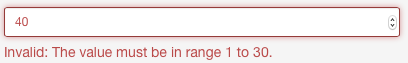
The input section of tool includes data validation of the inputs. The data validation checks the data type and the minimum and maximum if it is a number. The data validation also check whether or not the field is required. If any any of these conditions are not meet (text when it should be a number, too large of a number, etc.) it will give a warning in red below the field with details on why it has failed. It also outlines the field in red. Once the error in the data is fixed the box will be outlined in green. The required fields will only be validated if the user clicks on the field. If they do not click on the field there will be no error message. The tool tip will indicate what the minimum and maximums are.
Menu Boxes
The input section of the tool uses an according menu system. Only one menu box (set of inputs) can be open at a time. To open a menu box click on the title. This will close the previous menu box that was open. To close all menu boxes click on the text of the menu box that is currently open. Because opening a menu box closes another menu box the allignment of the top of the open menu box will move. In some cases the top of the menu box will be hidden above or below the current view. If this happens simply scroll up or down to reach the beginning of the menu box.
As-Built
As-bulit check boxes are used to indicate whether the data in a section is an estimate or it is the actual values. For specfics about how the as-bulit checkboxes work for each section including in the results see that section of the user's guide. As an example, in the standing corn row section the landowner breakeven costs is estimated based on yield, price, and inconvienece. The actual payment can be entered in this section. Checking the as-built button uses the actual annual payment amount in the outputs instead of the estimated cost. As-built is also used to indicate if a snow control solution was installed and which snow control solution was choosen.
Scenario Setup
Scenario Name
The name used in this field will be the name of the scenario in the drop down box. There are no restrictions on the characters used and can include space. Make sure that the name is descriptive but not too long. The name can be edited at any time.
First Year
Use this field to record the first year of the scenario. The default year is the current year. The minimum year is 2012.
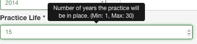
Practice Life
This is the useable life of the snow control practice in years. This field does not allow partial years and must be between 1 and 30 years. If you are evaluating more than one snow control practice then this should be the life of the snow control practice with the longest usable life.
State
This is the state that the scenario is in. It is preselected based on the State asscoiated with the agency account.
County
This is the county that the scenario is in. The list is based off of the selected state. The selected county is used to lookup county level data such as rental rates or yield.
Problem Segment
After selecting the state and county the problem segment drop down box will be populated with a list of blowing snow problem sites in that county for the agency. If the list is blank then there is no blowing snow problem data for this agency in the selected county. This field is not required to complete a scenario but is used to give suggested values based on data collected for the blowing snow problem segment. The drop down box is organized by roadway number and district. The name is the unique segment identifier and the milepost of the midpoint of the segment.
Snow Problem Area
Blow Ice
Checking this box indicates that there are blow ice events at this blowing snow problem site and adds the Blow Ice input menu box below snow and ice related crashes.
Drifting
Checking this box indicates that there are drifting now events at this blowing snow problem site and adds the Drifting Snow input menu box below snow and ice related crashes.
Snow Problem Length
This is the length of the blowing snow problem area in feet. This value is used to determine the distance of traffic slow down in the Traffic section and the length of sand and salt application in the blow ice section. It is also used to calculate the suggested value for the length of the blowing snow control solution but is not the same as the blowing snow control solution length. The suggested value is the value in the database for the selected snow control solution. The length must be in feet and rounded to the nearest foot. The minimum length is 0 and the maximum is 10,000.
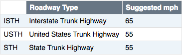
Road Type
The road type indicates the type of roadway. This is used to suggest a normal traffic speed in the Traffic section. The options are:
- Interstate Trunk Highway (ISTH)
- United States Trunk Highway (USTH)
- State Trunk Highway (STH)
- County Roady (CR)
- Township Road (TR)
- Other
Superelevated Curve
This checkbox is used to indicate a superelevated curve. In the agency paramaters there is two sets of snow and ice related crash reduction parameters. This check box indicates which set of crash reduction parameters to use.
Land
Land Rental Rate
The land rental rate is the market rental rate for an acre of land adjacent to the snow problem site. The suggested value is based on the county selected in the scenario setup. The data is the USDA average cash rental rate from the annual survey. The land rental rate is used to estimate the cost of land for a living snow fence and structural snow fence.
Land Value
The land value () is the market purchase price for an acre of land adjacent to the snow problem site. The suggested value is based off the land rental rate (
) using the following formula:
The suggested land value is the present value of the rental rate in perpetuity.
The land value is used to suggest a value for purchasing the right-of-way for grading based on the grading area in acres.
Crops
This section of the inputs allows for entering information about crops that are grown in the land adjacent to the snow problem area. To add a crop select the green "add crop" button below the crops section. To delete a crop select the red "X" to the right of the crop row you wish to delete.
Crop Name
The first step is to select the crop name. If the practice life is for just one year only select the crop that is grown that year. When evaluating standing corn rows for a single year this single crop should be corn. If analyzing standing corn rows for more than one year include the other crops that are rotated with corn over the time period. In the case of a multiyear analysis of standing corn rows with rotation the costs and benefits will be reduced based on the fraction of years that corn is planted. The idea here is that on years with no corn the costs and benefits will be zero. For example, the costs and benefits of standing corn rows in a multiyear analysis with a corn and soybean rotation will be reduced by 50%. The corn yield and price are used to calculate the cost of standing corn rows.
Yield
The yield for each crop is the yield per acre. The default yield is based on the county selected in the scenario setup and is in bushels per acre for all crops except corn silage (tons per acre). The default yield is the USDA yield data for each county. To reset the yield values to the defaults just re-select the crop name.
Price
The price for each crop is the dollars per yield. It is important that the yield unit and price units are the same. The tool does not handle until conversion. Any conversion must be done by the user. There are links at the bottom of the crops menu box to get current crop commodity prices. The prices at these links are in cents and must be converted to dollars.
Traffic
AADT
Annual Average Daily Traffic (AADT)– the theoretical estimate of the total number of vehicles using a specific segment of roadway (in both directions) on any given day of the year. This estimate represents the total number of cars per year divided by 365 and is developed using factors to adjust for season, day of the week, and vehicle type.
MnDOT (http://www.dot.state.mn.us/traffic/data/glossary.html)
The AADT includes all traffic even heavy commercial traffic. The AADT growth rate is the annual percentage growth rate in traffic. This can be determined by taking the two latest ADDT measurements (,
) and determining the annual growth rate (
) using the following equation.
In the analysis HCAADT is subtracted from AADT to estimate the non-heavy commercial traffic.
HCAADT
MNDot (http://www.dot.state.mn.us/traffic/data/glossary.html)
The HCAADT growth rate is the annual percentage growth rate in heavy commercial traffic. The growth rate can be determined using the same method as is described in the AADT section.
Time to Regain Bare-lane
The bare-lane-regain time is the time it takes in hours to regain minimum safe travel standards after a blowing snow event. The bare-lane-regain time is used to calculate the increased travel time for motorists as a result of reduced travel speeds following a blowing snow or ice event in a snow problem area.
Traffic Speed
Traffic speed is the average speed of traffic in the snow problem area under safe travel standards. If this is unknown the speed limit can be used. The suggest traffic speed is based on the roadway type select in the snow problem area section.
Traffic Speed Reduction
Traffic speed reduction is the reduction in travel speed in miles per hour following a blowing snow event. For example if the speed under safe travel standards is 55 mph and the speed after a blowing snow event is 35 mph then the traffic speed reduction is 20 mph.
Snow and Ice Related Crashes
The snow and ice related crash data for the following fields must be entered on an annual basis (i.e. number of crashes per year). If you have crash data that is not on an annual basis this must be converted by dividing the number fo crashes over time by the numbr of years.
Fatal
NHTSA, USDOT (http://www-nrd.nhtsa.dot.gov/Pubs/FARS06CVMan.pdf)
Incapacitating
NHTSA, USDOT (http://www-nrd.nhtsa.dot.gov/Pubs/FARS06CVMan.pdf)
Non-Incapacitating
NHTSA, USDOT (http://www-nrd.nhtsa.dot.gov/Pubs/FARS06CVMan.pdf)
Possible Injury
NHTSA, USDOT (http://www-nrd.nhtsa.dot.gov/Pubs/FARS06CVMan.pdf)
Property Damage Crash
Blow Ice
If this menu box is not visible then the Blow Ice checkbox was not checked in the Snow Problem Area section.
Equipment
This section of the tool records equipment usage that is used to treat blow ice in the snow problem area. To enter equipment that is used to treat drifting snow see the Drifting Snow section. Each column in the equipment table is for a different class of equipment. To add new equipment use the green Add Equipment button on the lower righthand corner. To delete equipment use the red X at the top of the column for the equipment that you wish to delete. The Equipment Class is selected in the second row and is generated from the list of available equipment for your agency. The equipment class determines the available attachments, the fuel use, and the cost based on the parameters set for your agency.
In the case where the equipment leaves a truck station, is used at a site and then returns to the truck station this is the round trip mileage. If there are multiple sites in which the equipment is used then the mileage should be just the portion that is associated with that site. It is up to the user to decide how to allocate mileage between the sites. For example lets say that there is Site A that is 10 miles from the truck station and Site B and additional 5 miles down the highway. Treating both sites takes 30 miles total (15 miles one-way). The user could assign the average miles per site (30 miles / 2 sites =15 miles per site) or could assign based on the extra distance that site adds on to the trip (20 miles to get to a from site A and an additional 10 miles to get from Site A to Site B.)
Equipment Rates
| Agency | Equipment Code | Description | Fuel Use | Fuel Use Unit | Rate | Rate Unit | Attach Code | Attach Description | Attach Rate | Attach Rate Unit |
| MNDOT | 330 | Single Axle | 4.79 | mpg | 5.53 | per mile | ||||
| MNDOT | 344 | V-Plow | 2.17 | per hour | 10.4 | per mile | 812 | V-Plow attachment | 0.06 | per hour |
| MNDOT | 350 | Tandem Axle | 4.25 | mpg | 5.36 | per mile | ||||
| MNDOT | 428 | Tractor | 0.39 | per hour | 87.33 | per hour | 830 | Rotary snow blower attachment | 0.53 | per hour |
| MNDOT | 620 | Motor Grader | 3.77 | per hour | 124.43 | per hour | ||||
| MNDOT | 710 | Small Dozer | 2 | per hour | 99.84 | per hour | ||||
| MNDOT | 760 | Loader | 2.2 | per hour | 123.63 | per hour | 832 | Rotary (2 stage) snow blower attachment | 6.79 | per hour |
| MNDOT | 880 | SnoGo Blower | 1.14 | mpg | 157.86 | per hour |
Events
The number of events in the blow ice input menu box is the number of events per year requiring sand and salt treatments for blow ice. This value is also used as the number of travel speed reduction events.
Treatments Per Event
The treatments per event is the number of sand and salt treatments per blow ice event. This value multiplied by the number of events is the total number of treatments per year for blow ice. The number of lanes is determined from the road type in the snow problem area menu box. The number of lanes is the number of lanes in one direction. So the number of treatments should count each direction separately. For example, if an agency treats a four lane highway with salt in both directions an average of four times per event then the number of treatments should be eight.
Application Rate
The application rate is the rate in pounds per lane mile applied to the roadway to treat blow ice. It is the total application rate of sand and salt.
Sand and Salt
The sand percentage is the percentage of the applied material that is sand. The tool assumes that the remaining component of the treatment material is salt. The percentage of salt is calculated by taking the percentage of sand and subtracting it from 100.
Drifting Snow
If this menu box is not visible then the Drifting Snow checkbox was not checked in the Snow Problem Area section.
Equipment
Entering equipment in the drifting snow menu box work the same way that it does for blow ice. See equipment section of the blow ice menu box in the user guide for detailed instructions.
Blowing Snow Control Solution
This section of the tool allows the user to select the blowing snow control solutions to evaluate. In order to evaluate a snow control solution the checkbox for that solution should be checked. This is required for the analysis and will also add the menu boxes needed for each particular snow control solution. This section also includes two user inputs in the menu box.To enter data in these the menu box must be opened to see them.
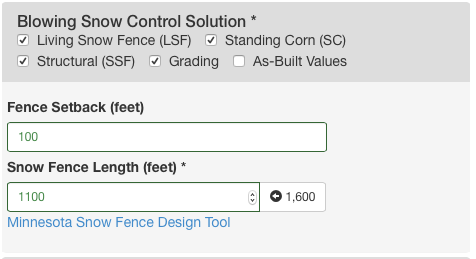
Fence Setback
The snow fence setback is the distance () from the edge of the roadway that the snow fence should be setback. This value is determined by estimating the maximum down wind drift length. Details about how this is calculated and for a tool to make the calculation for you in Minnesota see (http://climate.umn.edu/snow_fence/index.html). The equation to calculate the setback is below and uses the attack angle (
) and the porosity (
).
Snow Fence Length
The snow fence length is the total length of the snow fence. This length should be longer than the length snow problem area () in order to provide full protection given the setback. The Minnesota design tool can calculate the required extension from the acute and obtuse side of the problem area. Adding these two extensions plus the length of the snow problem area should be the minimum length of the snow fence. The suggested length of the snow fence (
) uses an attack angle of 90 degrees and a protection angle of 30 degrees.
This equation simplifies to
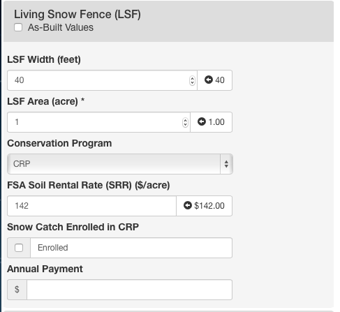
Living Snow Fence (LSF)
If this menu box is not visible then the Drifting Snow checkbox was not checked in the Blowing Snow Control Solution section.
LSF Width
The LSF width is the width of the snow fence including buffers on either side in feet. If the LSF in on agricultural land then it is the width of the area taken out of production. The suggested value is a default of 40 feet.
LSF Area
The LSF area () is the total area of the of the snow fence including buffers in acres. The suggested value is calculated from the length of the snow fence (
) and the width (
).
Conservation Program
The choice of the conservation program determines the fields and menu boxes that are visible.
FSA Soil Rental Rate
If this field is not visible then the CRP was not selected in the Conservation Program field in the Living Snow Fence (LSF) section. The soil rental rate is used to cost share the annual cost with the agency. This reduces the costs of the LSF to the agency. The suggested value is based on the average soil rental rate for the count selected in the basic setup section.
Snow Catch Enrolled in CRP
If this field is not visible then the CRP was not selected in the Conservation Program field in the Living Snow Fence (LSF) section. The snow catch enrollment allows the user to indicate that the area between the LSF and the roadway is also enrolled in CRP. This increases the cost of the LSF because additional agricultural land is taken out of production but also increases the cost share. The area for the snow catch CRP enrollment () is calculated using the following formula,
Rows of trees/shrubs
If this field is not visible then the EQIP was not selected in the Conservation Program field in the Living Snow Fence (LSF) section. This is the rows for trees and/or shrubs in the LSF.
Vegetation
If this field is not visible then the EQIP was not selected in the Conservation Program field in the Living Snow Fence (LSF) section. This is the current vegetation before installation of the LSF.
Site-prep method
If this field is not visible then the EQIP was not selected in the Conservation Program field in the Living Snow Fence (LSF) section. This is the method used to prepare the site for planting an establishment.
Annual Payment
The annual payment field is used if the annual payment to the landowner is known. This annual payment amount is the total annual payment to the landowner. This does not include payment for the establishment and maintenance of the LSF (To add values for this see the establishment and maintenance section). This value is used instead of the annual cost estimate from the rental rate and LSF area.
Installation Costs
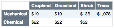
If this menu box is not visible then the Drifting Snow checkbox was not checked in the Blowing Snow Control Solution section. This section allows for entering installation costs in a number of different categories. The last category is an other catch-all category. The total installation cost is just the sum of all of the fields. The suggested value is based off an estimate of living snow fence costs from installations in Minnesota.
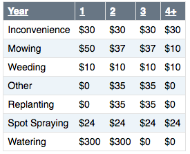
Establishment and Maintenance
If this menu box is not visible then the Drifting Snow checkbox was not checked in the Blowing Snow Control Solution section. This section allows for entering establishment and maintenance cost for LSF. The values are entered as total costs not per acre costs. The total maintenance cost per year is the sum of all the maintenance costs. The year 4+ column is the long term maintenance costs for years 4 and higher. The suggested values are calculated by taking the LSF acres and multiplying it by the per acre costs in the table below.
Yield Losses
The tool assumes yield losses near the LSF from competition or the lack of application of pesticides due to concern with over spray. To calculate the yield losses the following formula is used.
Where is the yield and
is the price of crop (
). The revenue is averaged over all the crops (
). The yield losses are 10% near the LSF. The area with yield losses is equal to a buffer of had the width of the LSF. So the area of yield losses is equal to the area of the LSF (
).
Annual Payment
If the total annual payment to the landowner or contractor is known it can be entered here. This value will override the estimate in the table above.
FSA CRP Cost Share
If this menu box is not visible then the CRP was not selected in the Conservation Program field in the Living Snow Fence (LSF) section. This section allows the user to enter FSA CRP cost share values. The first part of this section matches the installation section. The installation cost share amounts are subtracted from the installation costs to determine the agency costs. The suggested values are 50% of the installation cost values.
Agency Cost Share
The agency cost share is the reaming amount of the installation that the agency will be paying for. The suggested value is the total installation cost minus the total FSA cost share.
FSA Practice Incentive Payment
This is the FSA practice incentive payment. The suggested value is 40% of the total installation cost.
FSA Signing Incentive
This is the FSA signing incentive. The suggested value is $100 per acre.
Installation Cost Share (EQIP)
If this menu box is not visible then the EQIP was not selected in the Conservation Program field in the Living Snow Fence (LSF) section. This value is the cost share from NRCS for a LSF that is installed under the EQIP program. The suggested value is based on the following formula.
where is based on the selection of current vegetation and site prep method.
Standing Corn (SC)
If this menu box is not visible then the Drifting Snow checkbox was not checked in the Blowing Snow Control Solution section.
Row Width
The row width is the width in inches between rows of corn. The suggested value is a default of 30 inches.
Rows
Rows is the number of corn rows in the standing corn row fence. The suggested value is a default of 16 rows.
Width
This is the total width of the standing corn row snow fence. The suggested value is the width of the rows multiplied by 30 inches and converted to feet.
Area
The area is the total area of the standing corn row snow fence. The suggested value is the width
Annual Payment
The annual payment is the total annual payment to the farmer for leaving standing corn rows. It is not on a per acre basis. When a value is entered here the estimate is over ridden with this value.
Structural Snow Fence (SSF)
If this menu box is not visible then the Drifting Snow checkbox was not checked in the Blowing Snow Control Solution section.
Cost Per Foot
The cost per foot is the total cost for installation of the structural snow fence on a per foot basis. This does not include land costs
Width
The right of way acquisition width is the width of the land acquired for the structural snow fence. The suggested value is the a default value of 40 feet.
Area
The area is the total structural snow fence land area. The suggested value is based on the following formula.
Other
The other costs is a catch all field to add any other costs not entered above. This field can also be used if the total installation cost of the structural snow fence is known.
Annual Payment
The annual payment field is used if the annual payment amount is known. This value will override the estimate of the annual cost based on the rental rate and acres.
Grading
If this menu box is not visible then the Drifting Snow checkbox was not checked in the Blowing Snow Control Solution section.
Area
The grading area is the total area for grading in acres. Right of way The right of way costs are the total right of way acquisition costs. The suggested value is the grading aces multiplied by the land purchase price.
Earthwork
The earthwork costs are the total costs of all earthwork activities.
Other
Other costs a catch all field for any other costs not included previously.